Key facts about Saint Vincent and the Grenadines
| Capital | Kingstown |
|---|---|
| Continent | North America |
| Region | Central America and the Caribbean |
| Population | 99,924 2025, World Bank. 183rd of 195. |
| Area | 390 km² (151 sq mi) World Bank, surface area. 184th largest of 195. |
| Population density | 256 people per km² |
| Land neighbours | None. It has no land borders with another country. |
| UN status | Member state |
| Capital coordinates | 13.15° N, 61.21° W Kingstown, Natural Earth. |
No land borders
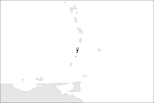
Saint Vincent and the Grenadines shares no land border with another country. Its nearest neighbours are across the sea, as the map above shows.
From the Geography app
The app teaches each country through short hand written lenses: PLACE for physical geography, STORY for history and identity, NOW for the news, and THREAD for the ties between countries. Here is one of Saint Vincent and the Grenadines's 5, in full.
A volcanic island trailing thirty-two smaller ones
The country is two landscapes under one flag. Saint Vincent is steep, wet and volcanic, rising to La Soufrière at 1,235 meters above black sand beaches. South of it the Grenadines run some sixty kilometers: thirty-two low, dry islands and cays, most of them empty, ringed by reef and sheltered anchorages that made the chain one of the world's charter yachting grounds. Bequia lies closest, Baliceaux just behind it, Union Island and the Tobago Cays farthest south.
More on Baliceaux
Baliceaux is a bare islet of about a square kilometer with no permanent population. In 1797, after the second of two wars against British forces, roughly five thousand Garifuna, the Afro-Indigenous people of Saint Vincent, were held there before deportation to the Bay Islands off Honduras. Perhaps half died on the island. Their descendants now number in the hundreds of thousands across Central America.
4 more lenses on Saint Vincent and the Grenadines in the app
Titles only. The app brings each lens back on a spaced repetition schedule set by how well you knew it: New, Hazy or Clear.
Compare Saint Vincent and the Grenadines with another country
Opens the country comparison tool with population, area, income and more side by side, every figure dated.