Cabo Verde is a country in Africa, in West Africa, with about 527,000 people (2025) and an area of 4,030 square kilometres. Its capital is Praia, and it has no land borders.
By Team Geography·Last reviewed
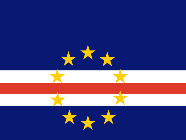
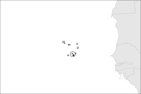
Flag of Cabo VerdeCabo Verde in solid, land neighbours outlined, capital marked.
4,030 km² (1,556 sq mi) World Bank, surface area. 166th largest of 195.
Population density
131 people per km²
Land neighbours
None. It has no land borders with another country.
Official name
Republic of Cabo Verde
UN status
Member state
Capital coordinates
14.92° N, 23.52° W Praia, Natural Earth.
No land borders
Cabo Verde shares no land border with another country. Its nearest neighbours are across the sea, as the map above shows.
From the Geography app
The app teaches each country through short hand written lenses: PLACE for physical geography, STORY for history and identity, NOW for the news, and THREAD for the ties between countries. Here is one of Cabo Verde's 17, in full.
PLACELens 1 of 17
Ten volcanic islands in the mid-Atlantic
Cabo Verde is an archipelago of ten islands and several islets roughly 570 kilometers off the West African coast, in the Atlantic west of Senegal and Mauritania. The islands are volcanic; Fogo last erupted in 2014. They divide into the windward Barlavento group to the north and the leeward Sotavento group to the south. Rainfall is scarce and droughts have been devastating. The mid-Atlantic position made the islands a critical waypoint for transatlantic navigation after Portugal colonized them in the fifteenth century.
More on Fogo
Fogo's Pico do Fogo reaches 2,829 meters, the highest point in Cabo Verde. Its last eruption in 2014 destroyed the village of Cha das Caldeiras inside the caldera, yet residents returned and rebuilt. The volcanic soil supports some of the world's most unusual wine production.
16 more lenses on Cabo Verde in the app
STORY A Creole nation forged between Africa and Portugal
NOW More Cabo Verdeans live abroad than at home
NOW A small island state punching above its weight
THREAD A bridge between Africa, Europe, and the Americas
PLACE Ten islands in the Atlantic
STORY A Creole nation of the sea
NOW The debut that did not stop at arriving
THREAD A team built by the diaspora
PLACE Windward and leeward
STORY Independence and a quiet democracy
NOW Remittances, tourism and a month of attention
THREAD The Lusophone Atlantic
PLACE The islands where Atlantic hurricanes begin
STORY The first European town in the tropics
THREAD A sea two hundred times the land
PLACE The islands get younger toward the west
Titles only. The app brings each lens back on a spaced repetition schedule set by how well you knew it: New, Hazy or Clear.
Compare Cabo Verde with another country
Opens the country comparison tool with population, area, income and more side by side, every figure dated.
Common questions
What is the capital of Cabo Verde?
The capital of Cabo Verde is Praia. Praia lies at about 14.9 degrees north and 23.5 degrees west. Cabo Verde is in Africa, in the region often called West Africa. It is home to about 527,000 people. The world capitals quiz on this site tests every capital, and the printable capitals sheets cover each continent.
What is the population of Cabo Verde?
About 527,000 people live in Cabo Verde, according to the World Bank figures for 2025. That makes it the 168th most populous of the 195 countries. With an area of 4,030 square kilometres, that is about 131 people per square kilometre.
What countries border Cabo Verde?
None. Cabo Verde has no land borders with any other country. It is surrounded by sea, so every neighbour of Cabo Verde is across the water. It lies in Africa, in the region often called West Africa. Its area is 4,030 square kilometres, and about 527,000 people live there.
How big is Cabo Verde?
Cabo Verde covers 4,030 square kilometres, or about 1,556 square miles. That makes it the 166th largest of the 195 countries. The figure is total surface area, which includes inland water such as lakes and rivers. Its population of about 527,000 gives a density of 131 people per square kilometre.
Cabo Verde is a country in Africa, in West Africa, with about 527,000 people (2025) and an area of 4,030 square kilometres. Its capital is Praia, and it has no land borders.
Capital
Praia
Continent
Africa
Region
West Africa
Population
527,326 2025, World Bank. 168th of 195.
Area
4,030 km² (1,556 sq mi) World Bank, surface area. 166th largest of 195.
Population density
131 people per km²
Land neighbours
None. It has no land borders with another country.
Official name
Republic of Cabo Verde
UN status
Member state
PLACE · from the Geography app
Ten volcanic islands in the mid-Atlantic
Cabo Verde is an archipelago of ten islands and several islets roughly 570 kilometers off the West African coast, in the Atlantic west of Senegal and Mauritania. The islands are volcanic; Fogo last erupted in 2014. They divide into the windward Barlavento group to the north and the leeward Sotavento group to the south. Rainfall is scarce and droughts have been devastating. The mid-Atlantic position made the islands a critical waypoint for transatlantic navigation after Portugal colonized them in the fifteenth century.
Keep going on your iPhone. Scan for Geography: the world, one country at a time, about five minutes a day. No quizzes and no streaks. playgeography.app/countries/cabo-verde/ · Map data: Natural Earth. Figures: World Bank and national sources, as listed on the page.
Geography · Country report
Cabo Verde
NameDate
Draw the flag
Colour Cabo Verde on the map, then fill in what you find.
Capital
Continent
Population
Area
Languages
Currency
Neighbours
Landmarks
Rivers or mountains
Three things I learned
1
2
3
One question I still have
?
Keep going on your iPhone. Scan for Geography: the world, one country at a time, about five minutes a day. No quizzes and no streaks. playgeography.app/countries/cabo-verde/ · Map data: Natural Earth. Figures: World Bank and national sources, as listed on the page.